
LiDAR Mapping for Drainage Problems You Cannot See From the Street
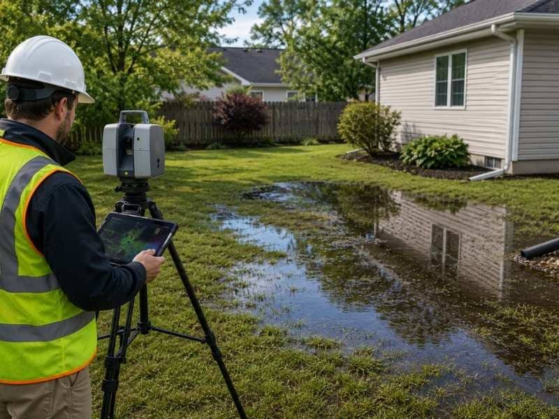
LiDAR mapping picks up details a property owner would never notice on foot. A few inches of elevation difference can decide where water collects after a storm. That gap is invisible from the street. LiDAR mapping closes it.
How LiDAR Mapping Helps Find Hidden Drainage Problems
A property can look level and still hide a drainage problem. LiDAR mapping works by sending laser pulses toward the ground. Those pulses bounce back at slightly different times. The result is a dense set of elevation points across the whole site. That’s far more detail than a visual walkthrough could ever catch.
That density matters. A dip of just a few inches can hold water after heavy rain. It rarely shows up to the naked eye. LiDAR mapping catches that dip anyway and shows exactly where it sits.
Hidden drainage problems matter because they don’t stay hidden. Standing water near a foundation starts this way. So does a patch that never quite dries out, or a slow erosion channel along a fence line.
Why Water Does Not Always Flow the Way It Looks
Ground that looks flat is rarely flat in reality. Most lots have small rises and dips spread across them. Water responds to every one of those changes, even when a person walking the property cannot tell they exist.
A slope of just one or two percent can send water down a specific path. That kind of slope is nearly impossible to spot without measurement. Add a driveway. Add a few years of soil settling. The grade can shift just enough to send water somewhere new.
This is why a property that seemed fine for years can suddenly grow a wet spot. One hard rain season is all it takes. The water simply found a path that was always there, just too subtle to see.
How LiDAR Mapping Supports Stormwater Planning and Resilience
Communities planning for stronger storms need more than a guess. They need to know where water tends to collect. LiDAR mapping gives planners detailed elevation data across large areas. That data makes it possible to model how water will move during a major storm before it happens. That kind of modeling helps planners spot which areas will flood first and where drainage capacity falls short.
Better elevation data also helps decide which drainage upgrades matter most. Not every project can happen at once. The data shows planners where the money is best spent first.
Places Around a Property Where Drainage Problems Often Begin
Drainage trouble tends to start in predictable spots. A closer look usually pays off near:
- Driveways, where pavement changes how water moves across the ground
- The back of buildings, where roof runoff concentrates in one area
- Ditches, where small blockages can redirect water onto nearby land
- Property lines, where grading on one side can affect the other
These spots deserve extra attention. They tend to see more grade changes, and a problem there costs more to fix. Trouble near a foundation or a shared boundary line escalates faster than trouble out in an open field.
How Land Surveyors Use LiDAR Mapping to Study the Land
Land surveyors use LiDAR mapping to build an accurate picture of a site. It often covers far more ground than a crew could measure by hand. The data shows every meaningful rise, dip and slope in fine detail.
That level of detail helps surveyors spot drainage concerns early. It also gives them a clearer read on site conditions. That insight supports better decisions about grading and land use. For larger or complex sites, LiDAR mapping changes the process from physical access to precise data.
Frequently Asked Questions
How can LiDAR mapping help find drainage problems that are hard to see?
LiDAR mapping records dense elevation data across a site. It catches small grade changes that a visual check would likely miss. Those changes often explain where water collects after rain.
Why do some properties have drainage problems even when the ground looks flat?
A slope of just one or two percent can send water toward a certain spot. That kind of grade change is nearly impossible to notice without measurement. The ground rarely looks as flat as it feels.
How is LiDAR mapping used for stormwater planning?
Detailed elevation data lets planners model how water will move during heavy rain before it happens. That helps them spot weak points in drainage capacity and decide where upgrades matter most.
Which areas of a property are more likely to have hidden drainage problems?
Driveways, the back of buildings, ditches and property lines tend to see drainage issues first. Grading changes in these spots have a direct effect on where water travels.
Why do land surveyors use LiDAR mapping when studying a property?
LiDAR mapping lets surveyors capture detailed terrain data across a site quickly. That helps them spot drainage concerns early and build a clearer picture of overall site conditions.