
How to Find Property Lines Before a Dispute Starts
Most property disputes don’t start with a lawyer. They start with a fence post. Someone installs one, a neighbor objects, and suddenly two people who used to wave at each other are arguing about who owns six inches of grass.
Knowing how to find property lines before any of that happens is the smartest move a developer or property owner can make. This article walks through exactly how to do it.
Why Property Lines Are Harder to Find Than You Think
Old records are messy. Many neighborhoods have lots that were surveyed decades ago, and those original markers don’t always survive. Storms knock them loose. Construction crews bury them. Erosion shifts them.
A lot of people assume the existing fence shows the real boundary. It often doesn’t. A previous owner may have installed it based on a guess, and that guess has been treated as fact ever since.
Online parcel maps are another common trap. They look accurate. They’re not legally binding, and the lines shown can be off by several feet. Trusting them before a build or a sale is a risk most developers can’t afford.
Where to Start Before Calling a Surveyor
Check Your Deed First
Your deed contains a legal description of the property. It may use metes and bounds language, which describes the boundary using directions and distances, or it may reference a recorded plat. Either way, it’s the starting point for any boundary research.
Pull the deed from your county’s property records office. Most are available online through the county’s property records portal. Read the legal description carefully. If it references a subdivision plat, pull that too.
Look for a Previous Survey
If the property was surveyed before, that document should be on file. Ask the title company that handled your last closing. Check with the previous owner. Licensed surveyors are also required to file their plats with the county, so a search through county records may turn one up.
A previous survey won’t always be current enough to rely on for construction or a dispute, but it gives you a strong starting point and may show where original monuments were set.
Check for Iron Pins on the Property
Property corners are typically marked with iron pins or rods driven into the ground. They’re small, easy to miss and easy to bury over time. A metal detector can help locate them.
If you find pins, don’t assume they’re yours. Confirm they match the legal description in your deed before relying on them for anything.
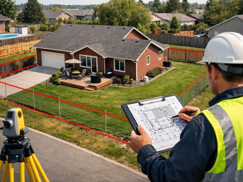
When You Need a Licensed Surveyor
Some situations call for a professional. No shortcut works here.
If you’re planning to build near a property line, you need a surveyor. Setback requirements are measured from the legal boundary, not from where a fence happens to sit. Getting this wrong means a permit rejection at best and a forced removal at worst.
If a neighbor is questioning your boundary, get a survey done before the conversation gets worse. A licensed surveyor’s findings carry legal weight. A printout from an online map does not.
If you’re buying land that hasn’t been surveyed recently, order one before closing. Boundary problems discovered after closing become your problem to solve, and they’re expensive.
A licensed land surveyor will research the deed history, locate existing monuments, set new ones where needed and prepare a certified plat. That document becomes part of the public record.
What Surveyors Find That Owners Miss
Older neighborhoods often have lots with descriptions written before modern GPS equipment existed. The measurements were done by hand, and small errors compounded over time. Two adjacent lots may have a cumulative error that nobody noticed until a fence went up.
Properties near waterways introduce riparian boundary questions. When a property borders a waterway, the boundary line can shift with changes to the water’s edge. That’s a legal and surveying issue most property owners aren’t equipped to handle on their own.
Dense tree cover and heavy vegetation hide markers that should be visible. Surveyors carry equipment that property owners simply don’t have.
How to Protect Yourself Before a Dispute Starts
Don’t wait for a conflict to start asking questions.
Get a copy of your deed and read the legal description. If you can’t locate the language describing your boundaries, contact your county’s property records office.
Look at the recorded plat for your subdivision if your property is in one. Plats show lot dimensions, easements and setback lines for the entire subdivision. They’re public record.
If you’re planning any work near your boundary, order a boundary survey before you start. The cost of a survey is a fraction of what a property dispute or permit correction costs.
Talk to your neighbors before you build. A simple conversation about where you both understand the line to be can prevent months of conflict. If there’s disagreement, that’s exactly when a survey matters most.
Document everything. If you find iron pins, photograph them with a reference point. If your neighbor makes a claim about the boundary, write it down with the date.
Frequently Asked Questions
How do I find my property lines without a surveyor?
Start with your deed and any recorded plat for your subdivision. Both are available through your county’s property records office. You can also look for iron pins at the corners of your lot using a metal detector. Online parcel maps are a rough reference only and shouldn’t be used for construction or legal decisions.
Are online parcel maps legally accurate?
No. Online parcel maps are useful for general reference but they aren’t legally binding. The lines shown can be off by several feet. For any construction, sale or dispute, you need a certified survey from a licensed land surveyor.
What happens if my neighbor and I disagree about the property line?
Order a boundary survey from a licensed land surveyor. Their certified findings are legally recognized and can be used to resolve the dispute without going to court. Acting early, before either party builds or removes something, makes resolution much simpler.
How long does a boundary survey take?
Most residential boundary surveys are completed within two to four weeks. The timeline depends on how far back the deed research needs to go and whether existing monuments are easy to locate. Properties with complicated histories or missing markers take longer.
Do I need a survey before building a fence?
Yes, and skipping it is a common mistake. If a fence goes up in the wrong location, you may be required to move it at your own expense. A boundary survey confirms exactly where your line sits before any money is spent on materials or installation.