
House Survey Red Flags in Flood-Prone Neighborhoods
A house survey shows you what a quick look around a property never could. In a neighborhood that floods, that matters even more. A house survey maps the land around a home and shows where water tends to go. It can point out low spots, weak drainage, and slopes that send water toward the walls. Buyers and owners use that picture to avoid an expensive surprise.
Signs a House Survey Can Find After Flooding
A house survey measures the exact height of the land at many points. That data shows where water collected and why it stayed. By eye, these clues are easy to miss, but on the map they stand out clearly. After a storm, the ground tells a story, and a survey reads it for you.
Watch for these warning signs in the data:
- Ground that dips below the road or driveway
- Soil that stays soft long after the rain stops
- Small channels cut by moving water
- A foundation with almost no slope away from it
- Land that sits lower than the lots next door
Once a survey marks these spots, you can deal with them before the next flood arrives.
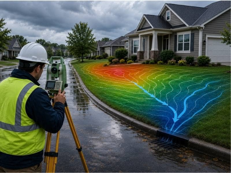
How Land Shape Can Affect Water Flow
Water always moves downhill toward the lowest point it can reach. The shape of your land decides that path. A slope away from the house carries rain out to the street or a drain, while a slope toward the house aims water at the foundation. Even a few inches of drop over a short distance can change the result. A survey measures these slopes, so you know where water will run before a storm proves it.
How Coastal Storms and Tides Raise the Stakes
Near the water, flooding comes from more than one direction. Rain fills yards from above, while high tides and storm surge push water in from below. When a strong storm meets a high tide, both forces hit at once. Low-lying lots flood first, because water gathers where the ground sits lowest. A survey shows how a lot compares to nearby land and to known flood levels, so the risk becomes a measured fact instead of a guess.
Problems to Fix Before Building or Making Changes
A survey done before you build can keep you from spending money in the wrong place. If the data shows a dip where you planned a slab, you can move the build or raise the grade first. You might also learn that a new patio would block the path water needs to drain. Fixing a drainage problem on paper costs far less than fixing a flooded room later. With the heights and slopes in hand, your builder can plan with the water in mind.
How a House Survey Helps You Make Better Choices
Buying or improving a home is a big decision, and guesswork tends to cost more. A house survey turns the land into clear numbers you can trust. You learn whether a lot drains well, sits high enough, and slopes the right way for the home on it. With those facts, you can ask the seller for repairs, adjust your offer, or step back with no regret. Owners who plan to stay can use the same data to guide upgrades that protect the home for years.
Frequently Asked Questions
What does a house survey measure?
A house survey records the exact boundaries, location, and ground heights of a property. The result is a clear picture of how the land sits and where its legal lines fall.
Can a house survey reveal flood problems?
Yes. By mapping ground height across the lot, it shows where water is likely to gather and which slopes may send runoff toward the home.
Will a house survey show how high the land sits?
Many surveys include elevation data that records the height of the land and key features. This lets you compare a lot to nearby ground and to flood levels in the area.
Is a house survey worth getting before buying a home?
A survey gives you real facts about the land before you commit any money. It can flag drainage or flood concerns that a normal showing would hide.
How do coastal storms and tides change flood risk?
Near the water, rain, high tides, and storm surge can raise water levels at the same time. Lots that sit low take on water first, so ground height plays a large role.
When is the best time to schedule a house survey?
The best time is before you buy, build, or make major changes to a property. Early data lets you plan around water issues instead of fixing them later.