LiDAR Mapping for Developers Planning Around Wetlands and Low Areas
Developers need to know where water sits on their land before they build. LiDAR mapping uses lasers to measure the ground and find wet areas and low spots. This helps developers understand where they can and cannot build. Wetlands and low areas have special rules that protect the environment. LiDAR mapping finds these areas so developers can plan projects that work with the land instead of fighting it. Understanding how LiDAR finds water and wet ground helps developers make smart choices.
See Wetlands That Are Hard to Find on the Ground
Wetlands are areas where water sits or flows slowly. They look different at different times of year. In dry months, wetlands might not look wet. In wet months, they fill with water. A developer walking the property might miss wetlands completely. LiDAR mapping finds them no matter the season.
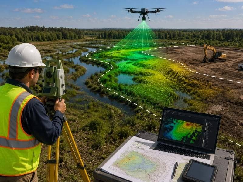
LiDAR sends laser beams down from drones flying overhead. The laser bounces off everything it hits. Trees, grass, ground, and water all reflect the laser differently. LiDAR measures how long the laser takes to bounce back. This tells the system how high or low the ground is. Dense vegetation and standing water show up clearly on LiDAR maps.
LiDAR also sees through trees to measure the ground below. In forests with heavy tree cover, you can’t see the ground from the air in regular photos. But LiDAR lasers go through leaves and branches. They show where wet areas hide under trees. This matters because many wetlands grow in forested areas where regular surveys miss them.
A developer can look at a LiDAR image and see exactly where the wet ground is. Areas that stay wet show different colors on the map. Dense trees that hide water underneath appear in the data. Developers know instantly where to avoid building.
Find Water That Collects in Low Spots
Water always flows downhill. It collects in the lowest areas of the property. During heavy rains, water that would normally soak into soil collects in these low spots instead. LiDAR shows exactly where these low spots sit.
LiDAR measures elevation, which is how high or low the ground is. On flat properties, small elevation changes matter. A difference of just one or two feet creates a low spot where water collects. LiDAR is precise enough to find these small differences. Regular ground surveys sometimes miss them.
Engineers use LiDAR data to trace where water flows. They start at the highest point and follow the slope downhill. They can see exactly where water wants to go. They can predict which low areas will fill with water during rain.
Low areas that fill with water affect building. If a low spot sits under a planned building, water can collect there. This creates flooded basements or wet foundations. If a low spot sits near a building, water might flow toward it. LiDAR shows all these problems before construction starts.
A developer who understands the low spots can change their building plan. They might move a building to higher ground. They might add drainage pipes to move water away. They might decide the low area should stay as a pond or water feature. LiDAR makes all these decisions possible.
Understand Rules About Building in Wetlands
Wetlands are protected by law. The government has strict rules about building in or near wetlands. Developers must know where wetlands sit before they can plan legally. Breaking wetland rules brings heavy fines and project delays.
Rules say you usually cannot build wetlands at all. You must also stay a certain distance from wetlands. This distance varies by state and local rules. Some areas require 50 feet. Some require 100 feet or more. The distance creates a buffer zone where you also cannot build.
LiDAR finds wetlands so developers know exactly where these buffer zones sit. A developer can see the wetland boundary and measure how far they must stay away. They can then decide where they can legally build on their property.
Wetland rules also limit how much you can change the ground. You cannot fill in wetlands. You cannot drain them. You cannot build dams or change water flow without permits. LiDAR data helps developers understand whether their project needs special permits.
See Why Ground Surveys Miss Wetlands
Walking the property to find wetlands sounds simple but it doesn’t work well. Wetlands change with weather and seasons. A wetland might look dry in August but be full of water in March. A surveyor visiting once might miss it completely.
Also, wetlands often grow in difficult places. They sit in thick brush or dense trees. A surveyor might not want to walk into these areas. They might miss the wetland simply because they didn’t go there.
LiDAR surveys the entire property at once. It doesn’t matter what the weather was when the survey happened. The LiDAR data shows the ground itself. It shows vegetation patterns that indicate water. It shows all low areas where water can collect.
LiDAR also creates a permanent record. You can review it months or years later. You can zoom in on specific areas. You can share it with engineers and permitting offices. A ground walk happens once and you only have field notes.
Plan Building Sites Away From Wet Areas
Smart developers use LiDAR data to pick the best building sites. They look at the LiDAR map and identify the highest, driest areas. They avoid low spots and wetlands completely. This keeps their project on schedule and within budget.
LiDAR shows areas that rarely or never have standing water. Developers build on these dry areas. They leave low areas and wetlands alone. Nature gets protected and the project succeeds.
Developers can also plan other uses for wet areas. A low spot becomes a pond for stormwater. A wetland area becomes a nature preserve. These features often add value to a property and satisfy environmental rules at the same time.
Using LiDAR to plan around wetlands from the start saves months of delays. No surprises. No unexpected wetland discoveries during construction. No expensive redesigns. No fights with environmental agencies.
Frequently Asked Questions
What is LiDAR mapping used for in wetland planning?
LiDAR uses laser measurements to find wet areas, low spots, and vegetation patterns that show where water sits on the property. Developers use this information to plan building sites that avoid wetlands and stay legal.
Can LiDAR find wetlands hiding under trees?
Yes. LiDAR lasers go through tree leaves and branches to measure the ground below. This helps find wetlands that hide in forests and thick vegetation where regular surveys cannot see them.
Why do ground surveys miss wetlands?
Walking a property works poorly because wetlands change with seasons and weather. Surveyors might visit when the wetland looks dry. Wetlands also grow in difficult places that are hard to reach on foot.
Does LiDAR show water boundaries exactly?
LiDAR shows elevation and vegetation very precisely. This lets engineers and planners identify where water sits and where buffers must be. However, official wetland boundaries often require additional study by environmental experts.
When should a developer get LiDAR mapping?
Get LiDAR mapping early in your planning. It shows you where to build and where to avoid before you spend money on design work or permits. This saves time and money on your whole project.