
New Flood Study: How a Topographic Survey Can Protect You
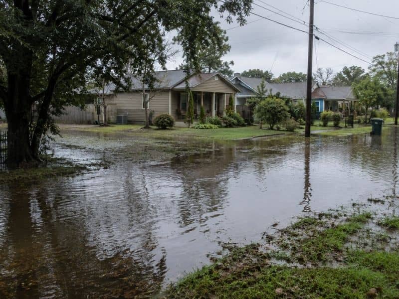
A new scientific study just put Mobile, Alabama on a list no homeowner wants to be on. Researchers at the University of Alabama published findings in the journal Science Advances in April 2026 showing that millions of Americans along the Gulf Coast face serious flood risk. Mobile was specifically named as one of the most vulnerable cities in the study. If you own property here, or are planning to build, this is the kind of news that should make you pay close attention to your land’s elevation. And that starts with a topographic survey.
What the Study Actually Found
A University of Alabama study published in April 2026 found that over 17.5 million Americans along the Gulf and Atlantic coasts are at the highest level of flood risk. Mobile, Alabama was named as one of the most vulnerable cities, alongside New Orleans, Houston, and Miami.
The research team used 16 different factors to calculate flood risk, including geographic hazards, population density, infrastructure exposure, and the vulnerability of residents themselves. They also pulled in historical flood damage data from FEMA and applied three separate artificial intelligence tools to model risk from Texas all the way to Maine.
The numbers they found were described by the researchers themselves as “alarming.”
- 17.5 million Americans are at “very high” flood risk along the Gulf and Atlantic coasts
- An additional 17 million are at the next level down, classified as “high” risk
- In New Orleans, 99% of the city’s population falls within the flood risk zone
- Mobile was named alongside Jacksonville, Houston, Miami, Norfolk, and Charleston as a highlighted city of concern
Study co-author Wanyun Shao, a climate scientist at the University of Alabama, put it simply. “Just look at the magnitude. Those numbers are shocking. Those numbers are alarming.”
For homeowners and developers, this is not abstract news. It is a direct signal that understanding your property’s elevation is no longer optional.
Why Mobile Is Especially Vulnerable
Mobile sits near Mobile Bay on low-lying coastal terrain and receives around 67 inches of rain per year, making it one of the wettest cities in the United States. Its geography makes accurate elevation data critical for anyone building or owning property here.
Mobile’s flood risk is not new. The city has always sat in a challenging position geographically. But the 2026 University of Alabama study reinforces what local surveyors and engineers have known for years. Small differences in elevation here are not minor details. They are the difference between a dry home and a flooded one, between an affordable insurance policy and a crippling annual premium.
The study’s researchers pointed to several factors that make Gulf Coast cities like Mobile particularly vulnerable.
- Sinking land caused by natural ground subsidence over time
- Dense urban development that replaces absorbent soil with hard surfaces
- Aging drainage infrastructure that was not designed for current rainfall intensity
- Proximity to tidal water that limits how quickly floodwater can drain
All of these factors interact with one central variable: the elevation of your specific property.
What a Topographic Survey Does That No Study Can Do For You
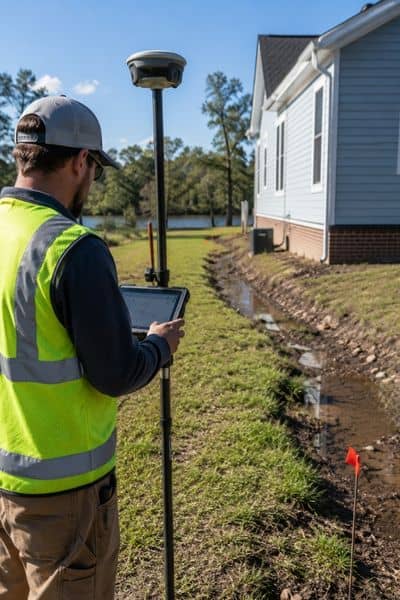
A topographic survey measures the exact elevation of your specific property and ties it to the same national standard FEMA uses for its flood maps. No regional study, no matter how comprehensive, can tell you what your individual lot’s elevation is. Only a licensed surveyor can do that.
The University of Alabama study is powerful because it looks at the big picture. But big-picture data cannot tell you whether your lot sits six inches above or six inches below the Base Flood Elevation for your street. That distinction determines your flood insurance rate, your mortgage requirements, and whether your finished floor ends up underwater after a heavy storm.
A topographic survey fills that gap. Here is what it gives you that the study cannot.
Your exact elevation, tied to FEMA’s standard. All topographic surveys are referenced to NAVD 88, the same vertical datum FEMA uses for its Flood Insurance Rate Maps. This means your surveyor can compare your property’s elevation directly to the Base Flood Elevation for your zone.
A drainage picture of your specific lot. The study identifies regional risk. A topo survey shows you how water moves across your individual property, where it pools, where it flows, and whether neighboring lots drain toward yours.
The data needed to fight a bad flood zone designation. If FEMA has placed your property in a high-risk flood zone but your elevation data shows you are actually above the Base Flood Elevation, your surveyor can use topo survey data to file a Letter of Map Amendment (LOMA) and potentially remove you from that zone. That one step can save hundreds or even thousands of dollars per year in insurance costs.
Documentation your builder needs before breaking ground. Architects and engineers use topo survey data to set your finished floor elevation correctly from the start. Getting this right before construction is far cheaper than correcting a drainage problem afterward.
The Real Cost of Ignoring Elevation
According to FEMA, about 25% of all National Flood Insurance Program claims come from properties that are not even in officially designated high-risk flood zones. That means a flood map alone is not enough to protect you. Elevation data from a licensed surveyor is the only way to know where your property truly stands.
Post-construction drainage repairs, when a home is built at the wrong elevation or without proper grading, can cost $10,000 to $30,000 or more. A topographic survey, by comparison, typically costs between $1,500 and $4,000 for a residential lot in Mobile. It is one of the most cost-effective steps you can take before any project begins.
What to Do Next
The University of Alabama study is a wake-up call for homeowners. But knowing that Mobile faces flood risk in general is only useful if you take action at the property level.
A topographic survey is that action. It turns regional flood risk data into specific, usable information about your land. It tells you where you stand, literally, and gives your builder, architect, and insurer the accurate numbers they need to protect your investment.
Frequently Asked Questions
Does the flood risk study mean my property will flood?
Not necessarily. The study identifies regional vulnerability, not the fate of individual properties. Your specific elevation, drainage, and proximity to water all determine your actual risk. A topographic survey gives you that property-level data.
Can a topographic survey lower my flood insurance costs?
Yes, in some cases. If your survey shows your finished floor elevation is above the Base Flood Elevation for your area, that data can be used to complete a FEMA Elevation Certificate, which may reduce your premiums. It can also support a LOMA application to remove your property from a high-risk flood zone entirely.
Should I get a topo survey even if my property has never flooded?
Yes. As the study shows, 25% of flood insurance claims come from properties outside high-risk zones. Past flooding history does not guarantee future safety, especially as rainfall patterns shift and development changes how water moves through Mobile’s landscape.