
How LiDAR Mapping Reveals Hidden Elevation Changes
Land does not stay flat for long. Soil shifts. Water moves. Heavy rain cuts channels into the ground. Years of small changes can reshape a site without anyone noticing.
A property may look level during a quick walk-through. Then construction starts. Suddenly crews find drainage issues, slope problems, or low spots holding water.
LiDAR mapping helps uncover these hidden changes before they become expensive surprises. It gives developers a clearer picture of what the land is doing and what may happen next.
Small elevation changes can create big project problems. LiDAR mapping helps spot them early.
What Is LiDAR Mapping?
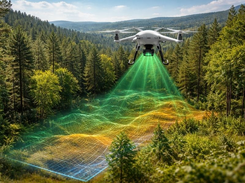
LiDAR stands for Light Detection and Ranging.
The process is simple. A scanner sends thousands of laser pulses toward the ground. Those pulses bounce back and measure distance.
The result is a highly detailed map of the land surface.
LiDAR can collect millions of elevation points in a short time. That creates a picture of the site that is far more detailed than what the eye can see.
Developers use LiDAR for:
- Site planning
- Road projects
- Drainage studies
- Land development
- Flood studies
- Large property mapping
How Hidden Elevation Changes Cause Problems
Tiny changes in height often go unnoticed.
A shift of a few inches may not seem serious. On a development site, it can create problems fast.
Water Starts Moving in New Directions
Water follows the slope.
Even slight elevation changes can send runoff toward roads, parking lots, or building pads.
That can lead to:
- Standing water
- Soil erosion
- Drainage failures
- Flood concerns
Many site problems begin with poor elevation data.
Grading Costs Increase
Developers estimate cut and fill volumes before work begins.
Bad elevation information creates bad numbers.
That often leads to:
- Extra hauling
- More equipment time
- Added labor costs
- Construction delays
Nobody enjoys finding out the dirt estimate was wrong.
How LiDAR Detects Changes People Miss
Walking a site has limits.
Trees block views. Brush covers low areas. Large properties make visual checks difficult.
LiDAR sees details hidden beneath surface conditions.
It Detects Small Ground Variations
LiDAR captures slight changes in elevation across large areas.
That includes:
- Small depressions
- Erosion paths
- Surface ridges
- Drainage channels
- Slope breaks
These details often affect site design.
It Works Through Vegetation
Heavy vegetation can hide important terrain features.
LiDAR systems can collect enough data points to help reveal the ground beneath tree cover.
This matters for wooded sites and undeveloped land.
A site can look smooth from above while hiding sharp terrain changes below.
Places Where LiDAR Finds Elevation Issues
LiDAR becomes useful in many project types.
Development Sites
Before planning starts, teams need to understand site conditions.
LiDAR helps identify:
- Low spots
- Drainage paths
- Existing slopes
- Areas needing grading
Early information helps avoid redesigns later.
Flood-Prone Areas
Flood risk depends heavily on elevation.
Even small terrain changes can affect how water spreads during storms.
LiDAR data helps teams study flood behavior before construction starts.
Large Tracts of Land
Large sites take time to survey with traditional field methods.
LiDAR gathers information quickly across wide areas.
That speed helps development schedules stay on track.
LiDAR and Traditional Survey Methods Work Together
LiDAR does not replace survey crews.
Field survey teams still verify control points and property information.
LiDAR adds another layer of detail.
Together they provide:
- Accurate elevation information
- Site measurements
- Boundary information
- Surface conditions
Good projects depend on good data.
Poor site information causes expensive mistakes.
Why Developers Order LiDAR Early
Developers often focus on design first.
That can create problems.
Early mapping helps identify issues before engineering plans move ahead.
LiDAR can help answer questions like:
- Does water naturally collect here?
- Will grading costs increase?
- Is this site truly level?
- Are there hidden drainage concerns?
- Will elevation changes affect design?
Finding answers early costs less than fixing problems during construction.
Frequently Asked Questions
What hidden elevation changes can LiDAR find?
LiDAR can detect low spots, erosion channels, drainage paths, small ridges, and subtle slope changes.
Can LiDAR see through trees?
LiDAR can gather enough data points to reveal ground conditions beneath vegetation in many areas.
Is LiDAR accurate?
LiDAR provides highly detailed elevation information when combined with proper survey control.
Does LiDAR replace land surveys?
No. Survey crews still provide field measurements, control points, and boundary information.
When should developers order LiDAR mapping?
Early in the planning process. Early mapping helps avoid surprises during design and construction.