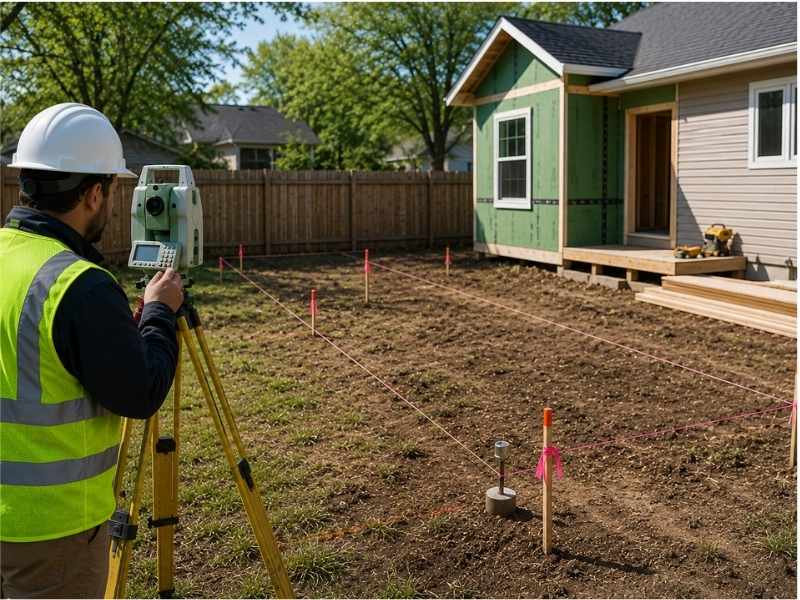
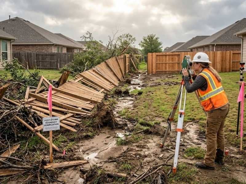
↓
 

Mobile Land Surveying

...local land surveyors in Mobile, Alabama.

Mobile Land Surveying
  • Home
  • ALTA Survey Mobile AL
  • Boundary Survey
  • Construction Survey
  • Drone LiDAR Mapping
  • Elevation Certificate | Flood Survey
    • Flood Survey
  • Land Surveying
  • Lot Survey
  • Topographic Survey
  • Mobile County, AL
    • Mobile, AL
    • Alabama Port, AL
    • Bayou La Batre, AL
    • Calvert, AL
    • Chickasaw, AL
    • Citronelle, AL
    • Creola, AL
    • Dauphin Island, AL
    • Eight Mile, AL
    • Grand Bay, AL
    • Mount Vernon, AL
    • Prichard, AL
    • Saraland, AL
    • Satsuma, AL
    • Semmes, AL
    • Theodore, AL
    • Tillmans Corner, AL
  • Baldwin County, AL
    • Daphne, AL
    • Fairhope, AL
    • Foley, AL
    • Gulf Shores, AL
    • Bay Minette, AL
    • Bon Secour, AL
    • Elberta, AL
    • Loxley, AL
    • Magnolia Springs, AL
    • Orange Beach, AL
    • Perdido, AL
    • Perdido Beach, AL
    • Point Clear, AL
    • Robertsdale, AL
    • Silverhill, AL
    • Spanish Fort, AL
    • Summerdale, AL
  • Jackson County, MS
    • Pascagoula, MS
    • Gautier, MS
    • Moss Point, MS
    • Ocean Springs, MS
    • Vancleave, MS
  • Washington County, AL
    • Chatom, AL
    • Leroy, AL
    • McIntosh, AL
    • Millry, AL
    • St. Stephens, AL
  • Blog
  • Contact Us
Home - Page 3 << 1 2 3 4 5 6 >>

Post navigation

← Older posts
Newer posts →

Land Surveying and GPS

Mobile Land Surveying Posted on June 18, 2017 by MobileSurveyorMarch 4, 2019
land surveying

Land surveying is a profession that greatly utilize the GPS system.

land surveyingToday, man-made constellations are in orbit. Their purpose is to provide instant, exact and global positioning information. This global positioning system of GPS is revolutionizing the modern construction sites, automating and guiding land surveying equipment, providing instantaneous circles and volume gap, simplifying total and controlled surveys. Nearly everyone involved in the land surveying and construction industry has heard something about satellite positioning technology or maybe you or someone you know is already using it. Whether an operator or a casual observer, there are still many questions about how this exciting system really works.

These positioning satellites don’t stay in one place like the stars; they orbit the earth about twice a day. Constantly transmitting uniquely identified radio signals that can be perceived by specialized units on earth. These signals are used to precisely measure the distance to the receiving instrument from each satellite visibly overhead.

Just as stars have exact locations in the sky, the locations of the GPS satellites are also defined, becoming orbiting reference points. Using a process based on triangulation, a GPS receiver processes the signals from multiple satellites to compute an accurate position on Earth, which is why it is widely use in land surveying.

For mobile applications that require high accuracy, such as three dimensional machine control, there are two requirements that must be met. First, the signals from a minimum of five satellites must be received at all times. And second, those five satellites must be distributed across the sky. This is called Dilution of Precision or DOP. The simple rule of thumb is this, the more satellites received the better your system will perform.

land surveyingAll land surveying receivers incorporate standard GPS tracking technology; unfortunately the GPS satellite constellation alone cannot continuously make the minimum requirement of accurate mobile positioning. For any given location, there are times in a day when there are less than five available satellites or very poor DOP.

Now, consider a land surveying job site with trees, buildings, or other obstructions when satellite receptions are easily be further reduced. All land surveying GPS receivers suffer this same problem because they all use the same satellites to operate.

Even the planned signal modernization to the GPS satellites won’t solve this problem. An obstruction that blocks one signal blocks all signals from that satellite. A land surveying equipment provider has solved this problem. The solution isn’t adding more signals from the same satellites; it’s adding more satellites.

Today, there is a second positioning satellite constellation in operation, the Glonass System. This positioning system is operated and maintained by the Russian government; much like the GPS is operated and maintained by the United States government; combining these two satellite constellations give land surveyors access to 38 different satellites; 14 more than a GPS-only system.

The additional satellites mean stronger and more accurate positions and better performance in obstructed land surveying areas. These additional satellites mean maximum up time in all land surveying locations, in all conditions.

For an up to date and accurate land surveying service, contact Brandon Bailey, PLS at (251) 281-2081 or better yet, you may fill out our contact form request and a licensed land surveyor will contact you. 

Posted in GPS, land surveying | Tagged GPS land surveying, GPS land surveying Mobile, GPS Mobile, Land Surveying, land surveying GPS, land surveying mobile, land surveyor, land surveyor mobile, Mobile GPS, Mobile GPS land surveying, mobile land surveying, mobile land surveyor

The Basics of Land Surveying

Mobile Land Surveying Posted on January 26, 2017 by MobileSurveyorJune 17, 2025

Land Surveying dates back to ancient history. Surveying is used for multiple projects.  A survey is done to establish a specific location of a parcel of land along with its exact acreage.  It is used to ascertain boundaries for defining an area of ownership and tax liability.  It is also used to identify a piece of property by a written legal description or to provide a review of the accuracy of an existing description. This data is of the utmost importance with regard to buying and selling land, and is also used to insure a clean and marketable title.

There are many different kinds of surveys that can be performed. A boundary survey is typically done for undeveloped land. This type of survey measures the actual physical extent of the property in question. Most surveys progress through the basic procedures regardless of the type being done. Any pertinent deeds, contracts, maps or other documents that contain a description of the property’s boundaries are located, studied and interpreted. A determination is made of what the actual property description is deemed to be, along with the locations of any physical evidence of the boundaries. This can be in the form of both natural and man-made monuments or markers that exist in the field. The property is then measured to establish the boundaries, not only using the appropriate existing monuments but with the creation and referencing of new markers where necessary. Measurements are accomplished using a total station and other surveying tools. A total station measures both vertical and horizontal angles, as used in triangulation networks. After these steps are accomplished, the property description and plat are prepared.

Interpreting the results of a land survey is not as difficult as it may first seem. For instance, a property plat will usually contain a directional orientation which is typically indicated with an arrow pointing north. It will contain the bearing and distance of each boundary line, the property lines of other properties shown on the plat, and the names of adjacent property owners listed in the areas of their property. Corner monuments, along with the names of any natural monuments (such as “Smith’s Creek”, for example) or a brief description of any unnamed natural monuments (such as the “30-inch pine tree”) are on the plat. There is also a title block containing the property’s location and name of owner, the surveyor’s name, the date the survey was performed, the scale of the plat and any other relevant data.

If you need the services of a land surveyor, ALWAYS be sure that you’re hiring an experienced, certified, and highly competent professional surveyor. You can find out if the surveyor is licensed by visiting the Board of Licensure’s website.

Please contact Brandon Bailey, PLS at (251) 281-2081 or fill in our Contact form to the right of this page.

Posted in blog, land surveying | Tagged a total station, boundary survey, land survey, Land Surveying, plat

Introduction to Mobile AL video

Mobile Land Surveying Posted on November 6, 2016 by MobileSurveyorMarch 4, 2019

Even though this video is a little old, it’s still a good video about our City.

I hope you enjoy it.

Posted in blog, land surveying | Tagged City of Mobile, Land Surveyor Mobile AL, Mobile, Mobile AL Land Surveyor

Post navigation

← Older posts
Newer posts →

Contact Form

    © Copyright Mobile Land Surveying
    (...a T. Brandon Bailey, PLS marketing website.)
    208 Mohawk Street
    Mobile, AL, 36606
    Phone: (251) 281-2081

    Web Development and SEO by:
    SEO Company for Professionals

    Terms of Use | Privacy Policy

    The owner of this website, USA Surveying & Engineering, LLC., provides coordination of professional land surveying and engineering services in all 50 states. The professional surveying and engineering services provided to you will be conducted by fully licensed professionals in your state.

    Privacy Policy
    ↑